 Reading time: 2 minutes

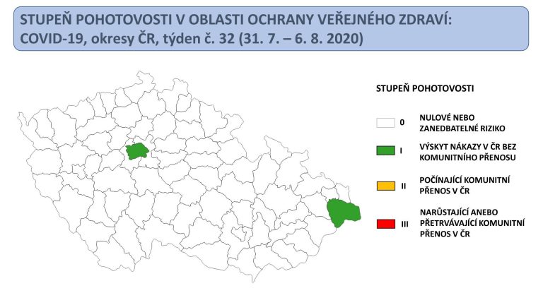
Prague, Aug 10 (CTK) – Only Prague and Frýdek-Místek (north Moravia) are marked as “green”, indicating increased COVID-19 risk, on the latest Czech “traffic light” map, compared with nine areas a week ago, the Czech Health Ministry said today.
All remaining 74 districts are white, which means a zero or negligible risk of infection.

The ministry updated the map based on the epidemiological situation in the country from July 31 to August 6, when its average number of new COVID-19 cases was 13 per 100,000 inhabitants.
In the Frýdek-Místek district, it was about 83 and in Prague 25 cases per 100,000 inhabitants.
“The only district with an unfavorable development is Frýdek-Místek, with significant increases in the number of newly confirmed cases and with the occurrence of significant clusters including those endangering vulnerable groups of inhabitants,” the ministry said.
In the district’s town of Jablunkov, dozens of new cases mushroomed, including 19 on Sunday, after the coronavirus hit a local old people’s home.
The reproduction number, i.e. the number of persons infected by one patient, has been rising in the Moravia-Silesia Region, in which Frýdek-Místek is one of six districts.
Regional Governor Ivo Vondrak (ANO) said today that the situation in the remaining districts is calm, including the Karvina district where coronavirus epicentre persisted in the past weeks. The OKD company’s coal mines, which suspended the mining over the coronavirus a few weeks ago, are starting to resume operation as of today.

According to sanitary officers, Prague has been oscillating on the brink of the virus’s community spread, as the authorities are unable to clearly define the source of infection of about 17 percent of cases.
“Since the trends are not escalating and there is no increasing risk for vulnerable groups of people, the number one (green) alert level has been issued for Prague,” the ministry wrote.
The number of new coronavirus cases started to rise in Prague sharply after a mid-July dance party where the infection spread among the participants. On July 21, there were 65 new cases in Prague and on July 24 there were 88. Afterwards, the number continued dropping to 26 on August 2, but last Tuesday, it was 79 again.
A total of nine districts appeared green in the map of infection last Monday: Prague, Frýdek-Místek, Prague-East, Prague-West, Brno-City, Ostrava-City, Karvina, Jihlava and Prachatice.
The “traffic lights” map has been based on the epidemiological development, a total of 25 parameters, in the past seven days. Trends are more important than the absolute numbers of infections, experts say.
Each risk degree carries a system of recommended anti-virus measures, the taking of which, however, is up to the relevant regional public health authorities.
The ministry presented the map on August 3 for the first time, and plans to update it every week.

The map divides districts into white, with zero risk, and green, yellow and red depending on the rising risk level. The green districts are those with new cases of the infection, which, nevertheless, do not spread in communities.